
The Driverless Digest - Autonomous Vehicles and Self-Driving Technology

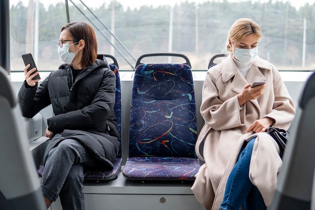

Choose the best autonomous driving option for your trip today to protect well-being and reduce injuries. Currently, the population of many cities fights peak-hour congestion, and a well-managed autonomous fleet can offer safer, more predictable trips for employees and residents with minimal disruption for businesses.
During a week with free rides, you can compare the types of services and decide which will deliver the greatest safety gains while lowering total cost for your company. Use clear safety metrics, ride reliability, and rider satisfaction to steer the decision.
For concrete planning, set a minimum standard: 99% trip completion, average wait under four minutes, and cost per mile under a sensible cap. Review performance per hour and compare with others in your region to refine deployment and protect population well-being.
Build with others by sharing results with city partners and data security practices, and invite input from employees to improve service design with transparency. thats why a staged scaling plan keeps risk in check while you extend service to more users.
Regulatory Compliance: How AVs Meet Legal Requirements on Public Roads
Adopt a formal regulatory compliance plan and publish a quarterly safety report. Assign a dedicated compliance officer and build a cross-functional team with employees from legal, safety, engineering, and operations to coordinate across offices in major markets.
If youre coordinating with regulators, maintain an auditable trail of decisions, tests, and updates that regulators can review. Investors, including musks and other tech groups, expect a clear regulatory path that reduces risk and speeds deployment.
- Build a single, auditable process that ties testing, deployment, filings, and data governance to every public-road operation, not to one-off pilots.
- Know the jurisdictional expectations: federal guidance, state permits, and city ordinances. Align training, insurance, and reporting with what each authority requires for driverless tests and commercial rides on roads and highway segments.
- Establish a safety case framework grounded in ISO 26262, ISO/SAE 21434, and SAE J3016, including hazard analysis, mitigations, and traceable evidence from both closed-track and on-road tests.
- Track metrics such as disengagement events, safety incidents, and system reliability; report progress publicly to build trust in markets that will adopt ride-hailing, taxi, and private-use AVs.
- Data and privacy: implement a data-minimization policy, retain logs for a defined period, and provide a privacy impact assessment for public review.
- Cybersecurity: maintain a software bill of materials (SBOM), enforce secure over-the-air updates, and run a vulnerability disclosure program; assess integrations with platforms like the apollo stack and other cloud services used by the fleet.
- Liability and insurance: align with state requirements for operator liability and ensure clear incident-notification timelines; specify who responds to incidents and how the public is informed.
- Public safety coordination: work with law enforcement, fire, and emergency medical services; incorporate emergency drills and communications for pedestrians, service animals, and dogs near test routes.
- Operational readiness: keep a safety driver or remote operator during initial deployments; run simulations and controlled road tests; train employees in decision making during edge cases; ensure driverless systems are running only under approved conditions; document all run logs for auditing.
- Transparency and communication: publish rider-facing safety briefs, provide a direct contact for regulatory inquiries, and explain how riders will be informed about ongoing tests on roads and highway segments.
- Fleet configuration: consider ride-hailing platforms such as uberxl and standard taxi formats to ensure the vehicle design and sensor suite support typical passenger loads and safety requirements.
- Market strategy: align development timelines with regulatory milestones in each market, from austin to other major cities, to minimize delays and accelerate deployment.
- Right of way: secure the necessary rights for road usage and ensure signage, lane marking compliance, and speed limits are consistently followed.
- Medical and accessibility: include emergency medical services coordination and accessibility considerations for riders with disabilities or medical needs to ensure inclusive service.
In practice, austin serves as a proving ground where regulators evaluate test processes, privacy controls, and emergency procedures before broader expansion. The best compliance programs combine formal control frameworks with clear public communications and continuous improvement loops; this approach keeps driverless fleets running on public roads while protecting riders, pedestrians, and employees alike.
Real-World Testing Protocols: From Simulators to Street Deployments
Start with a concrete plan: pair high-fidelity simulators with staged street pilots, and assign owners responsible for safety reviews at each hour of the ramp and at the end of every testing period, with very tight gates to stop deployment if criteria fail.
Design the protocol to cover dense urban corridors, busy arterials, and mixed traffic. Run ride-hailing trips with passengers in controlled conditions to observe how the tech handles complex turns, pedestrian gaps, and cyclist interactions. Track incidents such as near-misses, faults, and accidents; theres no room for ambiguity about sensor fusion and decision latency. Each trip demands careful review.
Build an auditable process: a central data hub ingests sensor and control logs, map data, and riders feedback; the trip records include a timestamp and a fault flag. Know where to look for faults and how the system is responding to events. The data backbone should support quick comparisons across different scenarios, from highway merges to dense city blocks. Need clear escalation paths for issues that require human oversight.
Engage owners and fleet managers early; shape a joined governance with city partners, regulators, and insurers. Align the join cadence with pilots: start small, period by period, and document who approves each step. A note: there are still concerns about privacy. There left some questions about data sharing, and the plan addresses them. The approach is mainly driven by safety metrics.
Compare outcomes against simulator forecasts to quantify gaps; past tests drew lessons about weather, lane width, and perception limits. Some issues left unresolved, but we address them with a policy runbook. Most teams report that a staged, measurable cadence reduces risk and builds rider trust. There are also clear signals about how riders and others experience the test.
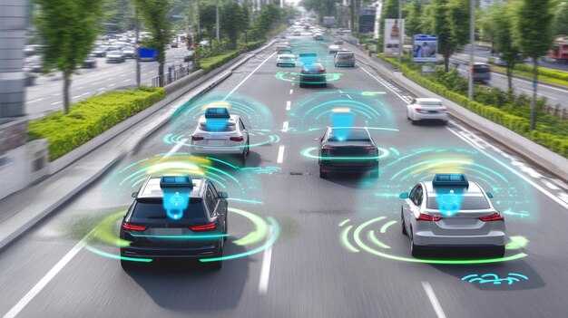
Sensor Suite Breakdown: LIDAR, RADAR, Cameras, and Sensor Fusion
Start with a balanced sensor suite: LIDAR, RADAR, and cameras, tuned for both dense urban streets and open highways. In american markets such as austin, this combination keeps ridesharing, taxi, and trucking service fleets operating safely while you build your data set and refine fusion rules. Currently, this setup provides robust redundancy and a clear path to reducing crash and accidents as you scale. First calibration runs establish the baseline before field deployment. Also, follow our newsletter for field-tested benchmarks across different vehicle types to guide your deployment decisions.
LIDAR and RADAR: complementary strengths
LIDAR delivers high-resolution 3D geometry: automotive units typically produce on the order of 1–2 million points per second, with 360-degree coverage and ranges around 100–200 m. It excels in static obstacle detection and precise mapping of street geometry, but performance can dip in heavy rain or dense fog. RADAR offers reliable velocity estimates and detection through adverse weather, with ranges commonly 50–200 m and good performance on metal and moving targets. Together they provide a robust baseline perception, letting the system track motion while preserving geometry for planning.
For deployments in ridesharing ecosystems like ubers or taxi fleets, allocate more weight to LIDAR geometry for path planning and use RADAR velocity cues to reduce false stops. When you compare different sensor configurations across markets, you’ll see that LIDAR-dominant setups excel in open lanes, while RADAR-backed systems reduce blind spots in dense traffic. Also, validate the fusion with real-world scenarios to minimize crash risk and ensure a consistent process for incident review.
Cameras and Sensor Fusion: turning perception into safe control
Cameras provide rich textures, color cues, and lane/traffic sign information. Monocular, stereo, and multi-view camera types each offer trade-offs in depth perception and redundancy. Typical automotive cameras run at 30–60 Hz with 1–2 MP resolution per sensor, delivering essential cues for object classification, sign reading, and semantic labeling that support decision-making. However, cameras degrade in glare and low light, so they rely on fusion with LIDAR and RADAR to maintain reliability.
Sensor fusion integrates signals through early, late, or hybrid approaches. Early fusion aggregates raw or near-raw data for unified perception, late fusion combines per-sensor detections, and hybrid fusion blends both to balance latency and robustness. Implement a consistent data-quality pipeline, including calibration checks, time synchronization, and cross-sensor validation, to keep the system resilient during dense urban ridesharing routes and long-haul trucking service corridors. Open testing records and transparent reviews help all teams learn from near-misses and reduce accident potential.
Decision-Making in Complex Environments: Path Planning and Hazard Handling
Implement a layered path-planning loop that reruns every 0.5–1.5 seconds, merging global routes with local obstacle avoidance. Rely on data from sensor fusion and open city maps to select the safest mile-by-mile path for each autonomous trip in the city. This approach keeps the fleet moving reliably, improves the ride experience for passengers, and allows offices to scale operations with limited compute budgets while still delivering consistent service. Over the year, trials with ubers and uberxl fleets show clearer, safer running patterns and fewer detours, increasing rider trust and trip success rate. This setup also helps teams stay sure about prioritizing safety.
Hazard handling runs as a dedicated robotic layer that detects pedestrians, cyclists, erratic drivers, and road incidents. When a hazard is detected, the system is designed for responding by decelerating, stopping if needed, or rerouting to an open corridor, then replan a safer path within 150–300 ms. The planner maintains a safety buffer of 2–3 seconds of travel time in dense city traffic. theres always a balance between responsiveness and energy use, so the system favors the path with the smallest safe detour. This approach reduces near-miss risk and keeps trips safer for passengers. It can offer safer detours and, in practice, the method works across most trips and reduces running detours that frustrate riders. This approach supports operations that work toward safer options.
Data governance and learning for continuous improvement
Set a governance loop across offices to monitor metrics, publish a monthly newsletter, and collect operator feedback. Known incidents inform quarterly updates to the planning model, and they use data from past trips to tune margins. Some stakeholders argued that open interfaces with city authorities and ride-hail partners helps harmonize routes and reduce friction around roadworks and events. there remains a balance to protect privacy while sharing aggregate insights. they also track performance to increase reliability and rider trust, especially for trips with passengers in ubers and uberxl.
Cybersecurity and OTA Updates: Keeping Vehicles Safe from Hackers
Enable automatic OTA updates to patch security flaws as soon as they are published. Currently, this reduces exposure within an hour of a critical advisory and keeps driverless fleets safe on highway corridors and during rides.
Adopt end-to-end code signing, encrypted update channels, and strict integrity checks so only authentic firmware is installed. Pair updates with signature verification, secure boot, and subsystem isolation to prevent fault propagation across running ECUs and other modules in the vehicle network.
Maintain a safe rollback plan: if a patch causes unexpected behavior, revert to a known good state with a one-click rollback. Run staged deployments, starting with early adopters and pilots, and then scale across city networks while tracking results in data dashboards shared by the company and its partners. Tekedra can provide guidance and testing frameworks to accelerate these efforts for american operators in many markets.
Costs for security can be minimized by designing OTA as a core service rather than a bolt-on feature. Most updates are free for owners under connected-service plans, yet operators should budget for security testing, signing infrastructure, and incident response. Data governance should limit telemetry to what is necessary, encrypt sensitive data, and implement access controls so data flows support safety without exposing riders to unnecessary exposure.
Across attempts to improve safety, cooperation among carmakers, ride-hailing platforms, and fleet operators matters. Since threats target both driverless and traditional systems, shared threat intelligence, standardized update protocols, and frequent security audits reduce risk across rides, highways, and urban corridors. Many american fleets benefit from transparent disclosure of vulnerabilities and rapid patch cycles, which lowers the chance of accidents caused by exploit chains and keeps services reliable for riders and drivers alike.
| Area | Action | Why it matters |
|---|---|---|
| Code integrity | Enforce strong digital signatures and secure boot; verify updates before install | Prevents tampered code and reduces fault risk |
| Update cadence | Patch within 24 hours of advisory; pilot longer windows for beta testing | Minimizes exposure window and improves stability |
| Secure channels | Use TLS 1.3, certificate pinning, hardware-backed keys | Protects data in transit and keys from interception |
| Rollback capability | One-click rollback to last good image | Mitigates faulty releases without disrupting rides |
| Monitoring | Real-time health metrics and anomaly detection | Early detection of suspicious activity or update failures |
| Privacy and data | Limit telemetry, anonymize data, restrict access | Protects rider privacy while preserving safety insights |
Insurance and Liability: Who Pays When Autonomy Takes the Wheel
Get an autonomous-vehicle policy endorsement that explicitly covers product liability, operator liability, and cyber risk; require terms that assign primary responsibility to the entity accountable for the fault, whether the maker, operator, or service provider, so payouts don’t stall at the first claim. For american fleets, this clarity helps keep the cost predictable and the support long-lasting.
Currently, liability frameworks vary, but AVs push the model toward maker or operator responsibility as levels rise. In SAE levels 2-3, the driver or attending operator bears more risk; in levels 4-5, the maker or fleet operator often takes primary liability for software bugs, sensor failures, and cyber breaches. Insurers price premiums by level, route profile, and use case, so fleets that run on busy roads and highway segments should expect tighter terms and higher deductibles for edge cases such as sensor glare in auroras or evasive maneuvers around seagulls on coastal roads, including urban corridors.
To reduce exposure, enforce robust data-sharing, event-logging, and maintenance records; require telematics that capture sensor status, software version, and fault codes. Consider apollo diagnostics and a long-term support plan from the manufacturer, plus a service-level agreement that keeps patches current. wheres the line between mutual insurance obligations and shared fault? Clear definitions cut disputes and speed payouts.
In case of a crash with injury or property damage, the insurer must assign blame promptly; this reduces the need for police reports and speeds medical care for hurt passengers. For others on the road, including pedestrians and traveling bystanders, extend liability coverage to medical costs, long-term impairment, and property damage. Cost-sharing may involve the manufacturer, the operator, or the policyholder, depending on fault and local law.
Fleets should set liability limits in the range of several million dollars, add umbrella coverage, and include cyber liability where possible. Push for data-driven endorsements that cover different road types, from urban streets to highway stretches. Build a plan that includes incident response, PR support, and police liaison guidelines. This approach helps reduce hurt outcomes and keeps a stable cost profile for american operators launching new services.
Maintenance, Diagnostics, and User Interfaces: Keeping AVs Reliable
Begin every shift with automated pre-trip diagnostics that verify sensor feeds (lidar, cameras, radar), check compute module temps, battery health, and network latency. If a fault appears, youre warned with a plain-language alert and the vehicle enters safe mode, keeping traveling risks down.
Diagnostics workflow
- Sensor health and fusion: verify each feed, target average latency under 20 ms for cameras and under 25 ms for lidar; keep dropout under 0.2% and confirm fusion outputs with a 3-sensor cross-check so knowable alerts come with actionable context.
- Thermal and power: keep compute temps under 75 C, GPU/CPU under 85 C during peak load; battery state of charge (SOC) above 25% or provide a safe fallback plan if below 20% in urban corridors. This helps reduce risk during a trip, especially if the route is long.
- Network and latency: ensure 5G/DSRC connectivity with end-to-end latency under 50 ms; packet loss under 0.1%; emergency remote-control path open.
- Calibration and wear: camera calibration drift within 0.1 degrees monthly; wheel alignment within 0.1 degrees; replace worn tires or sensor mounts per mileage bands (e.g., every 20k miles); dust, musks, and grime on seals get covered in preventive checks.
- Software rollout and integrity: track rollout progress so that higher percentage of fleet runs on the latest stable code within 14 days; verify the release on Waymos hardware; ensure a rollback path and test in a safe sandbox before pushing to roads. Thats why developers run staged tests, and this helps with safer open-rollouts in development cycles.
- GPS redundancy and auroras fallback: if GPS degrades due to auroras or urban canyoning, switch to inertial navigation and map-based corrections; log any drift for analysis.
- Data retention and audit: store logs for at least 60 days for incident reviews; keep 6 months of critical event summaries; ensure that audits can be traced without exposing riders data.
- Past fault review: identify and cover the top 5 causes seen in past deployments to avoid repeating them; share learnings with development teams so the average rides rise.
- Open fault graph: automatically link detected faults to a service queue; nobody should ride in a vehicle with an unresolved safety issue; the system should open a ticket for rapid responder teams.
UI and rider interaction
- Open, clear status indicators: green means sensors healthy, amber signals a warning, red indicates fault; these indicators appear on the main HUD and in the rider app so they know exactly what to expect and when to prepare for a safe stop.
- Trip prompts and controls: present concise, action-oriented prompts; for example, "Proceed with current route" or "Switch to safe stop." Use large tap targets to help riders pick options quickly.
- Rider input and feedback: allow riders to report issues via voice or app; their input triggers a quick diagnostic check and a humane response from staff if needed; free-form feedback is encouraged.
- Dogs and cabin comfort: adjust climate seating to accommodate dogs; offer a pet-friendly mode and reminders about cabin cleanliness after trips with animals; this open approach reduces stress for riders, dogs, and staff.
- Network join and data sharing: riders can opt to join the vehicle's network to receive trip updates and route information; open data policy and privacy notes are shown in-app; they can disconnect anytime.
- During travel: audible prompts and simple icons help navigate stops; if a fault arises, the UI guides them to a safe stop and informs them of the expected remediation time so they remain calm.
- Language and accessibility: provide multiple languages and high-contrast options; ensure that alerts use simple vocabulary; support color-blind palettes and screen reader compatibility.
- Performance metrics: report uptime, the percentage of trips started without alerts, and response times to rider inputs; these metrics show that the system supports smooth traveling and a stable rollout.
- Open collaboration: teams can join the network to respond to flagged rides; riders know they will be supported if something goes wrong; this openness reduces anxiety during trips.


